

Click here for comments on this paper by David Johnson

The word 'Spechscaflade', that appears in 'The Coucher Book of Furness Abbey' relating to the Southerscales boundary perambulation dated January AD 1250/1251 (Brownbill, 1916) was first proposed as possibly 'speech staff' - that is a 'post at which speeches were made' + lade = 'watercourse' by A.H. Smith (Smith1, 1961). Elsewhere Higham continues with this meaning in her paper for Lancaster University's Centre for Northwest Regional Studies (Higham, 1992). The word is chronicled again in the Coucher Book, in a perambulation of 1220 where the word is spelt 'Spechscaflad, (ibid pp 341) and in the reign of Henry 1V (AD 1399 û 1411) it is spelt 'Spethscaflade' (Atkinson, 1886). Two other, later boundary perambulations * NB give another term for the same position on the boundary. The 1685 perambulation states;
"....(from) the great graystone on the north side of Great Ingleburrow and thence to the Hurle above Holmsfold and from thence to Spinescarr loud or lade where we set and repaired an ancient Mark or Meer and from thence to the head of Moorbeck." (my emphasis)
A perambulation in 1739 states;
"....thence over the east part of Ingleborrow Hill to Cawdwell Kutt and so down Mear Gill." (my emphasis)
These different names seem to suggest that the upper part of the stream, before it reaches Meregill, has changed names several times, with the Spechscaflade being the oldest known written name.
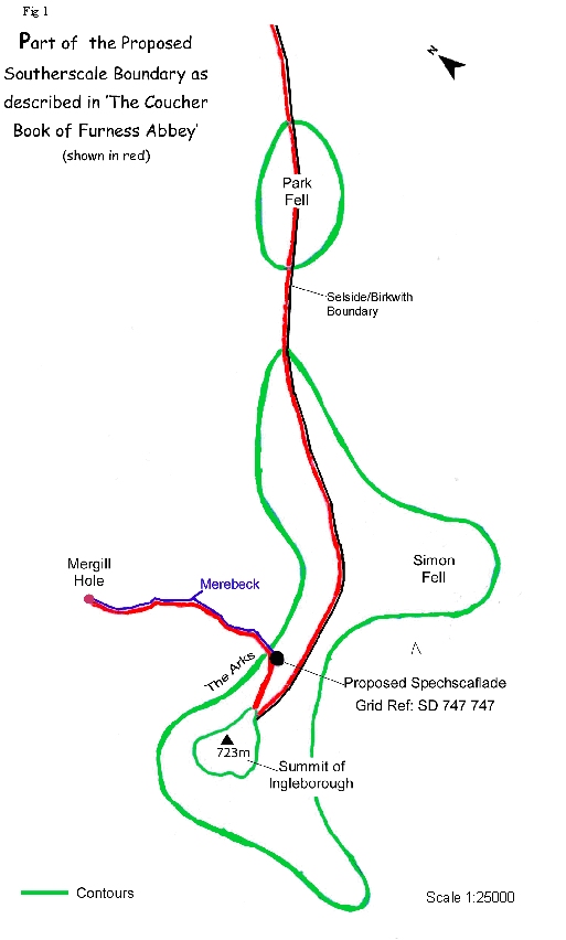
According to the Coucher Book, the 'Spechscaflade' is located between the summit of Ingleborough and 'Morebech' Photo of proposed Spechscaflade
identified by Higham as the present day Meregill, (Higham 1992) meaning 'boundary stream' (Holinshed, 1577 in Smith2, 1962) Higham describes a small whale-shaped limestone inlier (Fig 2), with a slightly dished spine, at Grid Reference SD747747, as the location of the Spechscaflade. The Coucher Book clearly describes the boundary going 'from the high part of Ingeburg all the way to Spechscaflade and thence all the way to Morebech and so by, (or by means of) (or along) Morebech all the way to Witfalles'... ( In original Latin 'videlicet a supercilio montis de Ingeburg usque ad Specscaflade et inde usque ad Morebech et sic per Morebech usque ad Witfalles'..). Higham's use of Meregill for 'Morebech' is given further credence as, in the 1220 version and the later document from the time of Henry 1V, this same stream is spelt Merebek. It is the only stream that starts near the summit of Ingleborough (on this boundary) and flows down the full length of Meregill, exactly as the perambulation describes (Fig 3) and (Fig 4).
Taking the documentary evidence, and assuming that Mary Higham has correctly identified the stream as Meregill, does this location for the Spechscaflade, seem reasonable? As this landscape feature is at a point where the boundary would turn to go down hill along Meregill and is also the place where the stream rises (Fig 5), it would seem obvious, or at least very likely, that a boundary feature would be mentioned at this point. There is no other significant feature at this location.
However, reading further on, in the Southerscale perambulation, there is no mention of the Spechscaflade as the boundary returns to the summit of Ingleborough, At first glance this may seem to be an anomaly. However, the Coucher Book states that the boundary returns to the summit of Ingleborough along the Selside boundary by the upper crest of Langhals, that we take to be Park Fell. Fig 6 clearly shows an upper and lower crest of the western side of Park Fell with the Spechscaflade situated on the lower part. We are of the opinion that the Selside boundary is on the upper crest, as stated in the boundary perambulation. Being further to the east it would not return to the Spechscaflade and would leave a narrow strip of land to the summit of Ingleborough within the Southerscales boundary (Fig 7). This makes sense, as it would be reasonable to assume that all boundaries emanating from, and terminating on, Ingleborough would include access to the summit.
The meaning of the word 'Spechscaflade' is much more problematic. Smith does not explain how he arrives at the term 'speech staff' and there are no diacritical marks in the original word to help with the meanings. Smith analyses elements of place and field names in Vol 36 Part 7 (Smith2). He has nothing listed for Spech but has spēc = speech (page 247). There are two words listed that he could have used for the 'staff' part of the word sceaft = shaft or pole (pp 240) and staef = staff, stave or rod (pp 248). 'Sceaft' is translated to a shaft or a pole, but can also mean 'origin' or 'creation' - not mentioned by Smith. In an earlier publication (Smith3, 1956) 'sceaft' is defined as 'a shaft or pole, probably used of a pole acting as a landmark or a boundary post'. In this volume, on page 136, Smith also has a term for a place where people assemble for speech-making (spell-stōw). This translation of Smith's is confirmed in A Concise Anglo Saxon Dictionary (Clarke Hall, 1855) where the word is defined as a 'place of proclamation'.
A search on the Old English translation site www.oldenglishtranslator.co.uk came up with nothing for the 'Spechscaflade'. Broken down into syllables nothing came up for Spech, scaf, Spechscaf and only 'watercourse' for 'lad' but a term 'meaning to draw up water' also had this root. We couldn't find any term relating to 'speech' from this site. Entering the phrase 'speaking at a place near a stream' in Modern English gave dozens of modes of speaking including a place for speaking (courthouse) 'spraecaern'; 'a senate house for speaking1 or auditorium2 spraech·s. Incidentally entering in Modern English 'speech staff' gave no translation in the O.E. but did give many examples of modes of speaking, including one for a council meeting or popular assembly (maeoel). If holding a speech staff during discourse was widespread in the government or leadership of the times then surely, within the richness of the language for modes of speech, there would be a term for it, but from our investigations, Spechscaflade seemed a unique term.
In her article for Northwest Regional Studies (mentioned in the first paragraph), Higham also states that a 'staff of government' is known from the Isle of Man, however she does not give the term used. Looking up this reference (Megaw, 1978) , does not really add much to the debate, as Megaw is describing the Tynwald assembly (Tingvalla). The name refers to the 'untilled field or plain on which the midsummer assembly gathered' (page 287). On top of a hill, that is thought to be a burial mound, a pavilion is erected where open-air meetings are held. It was at this place that the recognition of the heir apparent took place by the passing of 'the staff of government' this being a 'long white rod'. We also checked the word Tinwall this translated as an open area, or in a valley , where people assembled, It is plain to see, from these descriptions, that their locations have nothing in common with the 'Spechscaflade' (Fig 8).
In a description of a boundary, the natural features are more likely to be described, than a speech staff or a meeting place, as the landscape is more permanent and less transient. Of course the possibility of it being an ancient place where there used to be a speech staff cannot be totally discounted This does not mean that meetings would be held at the speech staff or pole, but the staff could have a flag on top, and when this was flying it may have summoned people to a pre-determined place where gatherings were held. But with the confusion over the translation it cannot be taken too seriously. Perhaps the term is so old that nobody from this period knew what it meant, just as most people accept place names today, unless they happen to be interested in studying etymology. The other point to bear in mind is that the spelling is probably phonetic and this could be the reason no translation could be found on the Old English Translator site. We spent some time researching whether it could be derived from another language such as Old Norse or even Gaelic, but this proved inconclusive.
In our opinion, taking into account the physical nature of the site, the most likely translations of the word is 'Spech' = place; 'scaf' = crooked or, if derived from 'sceaft', origin or a boundary pole; lad(e) = water course, way or stream. This would make the source or 'origin' of Merebeck into the Spechscaflade and not the limestone knoll, or alternatively the 'place where the boundary turns (marked by a pole?)' at 90░ to go along Merebeck, essentially these are one and the same point. The later names of Spinescarr and Cawdwell Kutt also indicate this to be the feature, as the stream does indeed create a scar on the 'spine' of Ingleborough and the cold spring or well creates a 'cut' at the top of the western slope of the hill.
Our translation fits the word to the topography and it is dangerous for historical and archaeological research to go beyond this point and create another meaning for Spechscaflade without more evidence. To do so will create more confusion, and result in articles being written that may become accepted without being questioned, as so often happens.
Believing, as we do, that evidence is important before accepting any specific theory, and taking into account that even our research showed there was considerable doubt about the translation, we decided to contact Oxbridge Editing (www.oxbridgeediting.com ) to obtain a translation or some advice about the origin of the word. A prominent Oxford Professor, a specialist in O.E., looked at the extract from the Coucher Book containing Spechscaflade, and gave his opinion. We have published his reply below, with his permission and in its entirety, in the interest of impartiality and to liven the debate. We also endorse the recommendations in the last paragraph of his reply.
OxBridge Editing Order Ref: OXE 11994
The word 'Spechscaflade' is what Anglo-Saxonists call a 'hapax legomenon', meaning that it occurs only once in written record. I cannot recommend a conclusive translation to be inserted into your translation from the Latin, because I believe it to be a place name whose elements have only likely and not definite meanings. It is also quite possible that it features words that have not survived in record today but had a clear meaning at the time. We can, however, speculate about the word's origins, which might be interesting or useful to your studies of the area.
Firstly, the 'spech' element. Using the Old English etymological dictionary of Ferdinand Holthausen, Altenglisches Etymologisches Worterbuch, (Heidelberg: Winter, 1934), I think your best bet would be the entry recording 'specca' = spot, place (cf. ModEng 'speck'), but also 'spec' = 'spic' =pointed piece of land, spelt in Middle English as 'spich', which is very similar to your example. 'Spech' is also a form of the Scots word 'spek', meaning a blot or discolouration. Scots also uses 'Spech' to mean 'speech', which is presumably where Smith got his translation from. To my mind, however, the Old English meaning of 'place' seems likeliest.
The 'scaf' element is more complicated by the fact that the spelling is interchangeable with 'sceaf'. Holthausen has Old English 'scaf' (with long a) for German 'schief' = crooked, leaning, not straight; this could fit with the translation for 'spech'. Holthausen also gives 'sceaf' = sheaf, bundle, tuft. It is impossible to say which word is indicated here. It seems that Smith got his meaning 'staff' from assuming that 'scaf' is a corruption of 'sceaft', which I would hazard to be mistaken.
A different meaning is displayed in the Birch Charter of 1319:
Ch 811 (Birch 1319) B15.8.414
1. [0010 (13)] Of sµdeles steorte innan dosaburnan andlang dosaburnan hutan esc for hup to acsceates geate of acsceates gate on sceafles oran foreweardne of sceafles oran on hwoburnan andlang burnan huton heofes brycce andlang scyre on hweeles heal of hweeles heale &lang burnan.
The usage here apparently describes a unit of measurement for ore. I don't know if this is industrially relevant for the area you are looking at here.
The final element of the word is the most easily translated. In this context, it is likely that the 'lade' component means 'path', or 'way', or 'course'; for example, the Old English sentence 'lad over lagustream' means 'the way over the water' (see entry in the standard Bosworth Toller dictionary (http://beowulf.engl.uky.edu/~kiernan/BT/bosworth.htm, which is a useful resource for these kinds of enquiries). 'lade', however, is a very commonly found joined to other words to form a compound, known as a 'kenning'. For example, the word 'sµlade' means 'the way over the sea'. This might suggest a kind of boundary, path or bridge related to the 'Spechscaf' part of the word.
Holthausen has 'lad'= journey, path, way, leading, street, ditch, stream; ModEng 'load'. Smith seems to have continued on his Scots analysis, taking 'lade' to mean 'water-course' (one of its Scots meanings) which is closely related to the Old English meaning and also quite possible û it all depends on the dialect of the person who coined the name for the site.
So, we might conclude that the place name seems to reference 'place' and a 'path' at that place. This path might reference a path that was literally worn away at the time to form a kind of boundary that is no longer there and therefore topographically untraceable, 'scaf' might suggest that either the place or the path was crooked, or that it was related to sheafs/tufts/bundles or ore production.
It is also quite possible that 'Spechscaf' was somebody or something's name and that the path or way or watercourse belonged to or was associated with them. The place-name could therefore mean 'Spechscaf's path' or 'the path to Spechscaf' et cetera.
I am sorry that I cannot recommend a conclusive translation. However, I think it would be an interesting and wise editorial action to preserve the Anglo Saxon name in the passage (with an explanatory footnote) in the interests of diversity and indeed in accurately culturally representing the document you are translating. I hope my research has been of some help to you.
Best wishes,
The Editor
Fig 1.The Proposed Spechscaflade (to the left of the green hump in the centre)
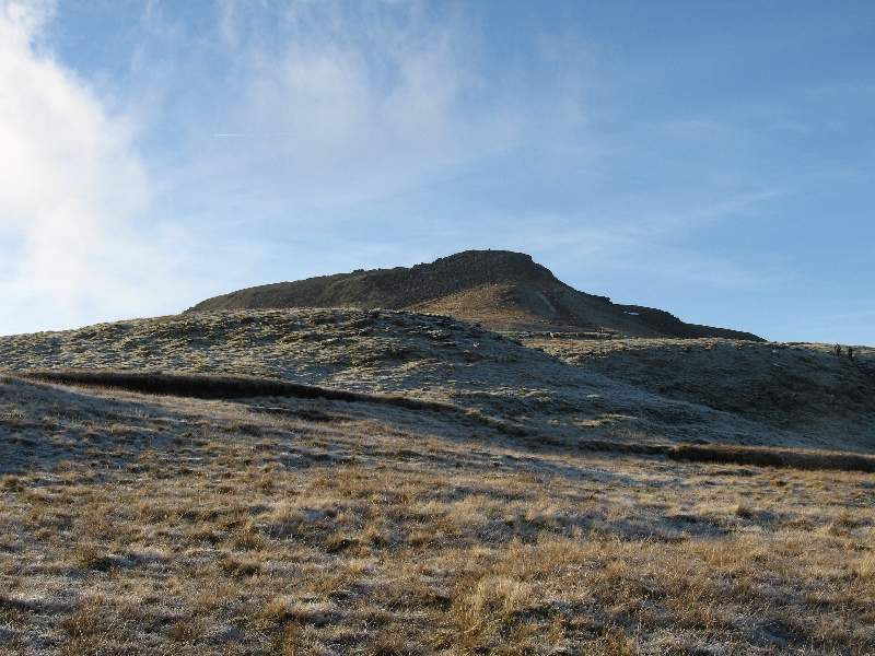
Fig 2. The "Spechscaflade" - a limestone inlier as described by Mary Higham, with the summit of Ingleborough in the background.
Merebeck rises at the base of the limestone (centre right.)
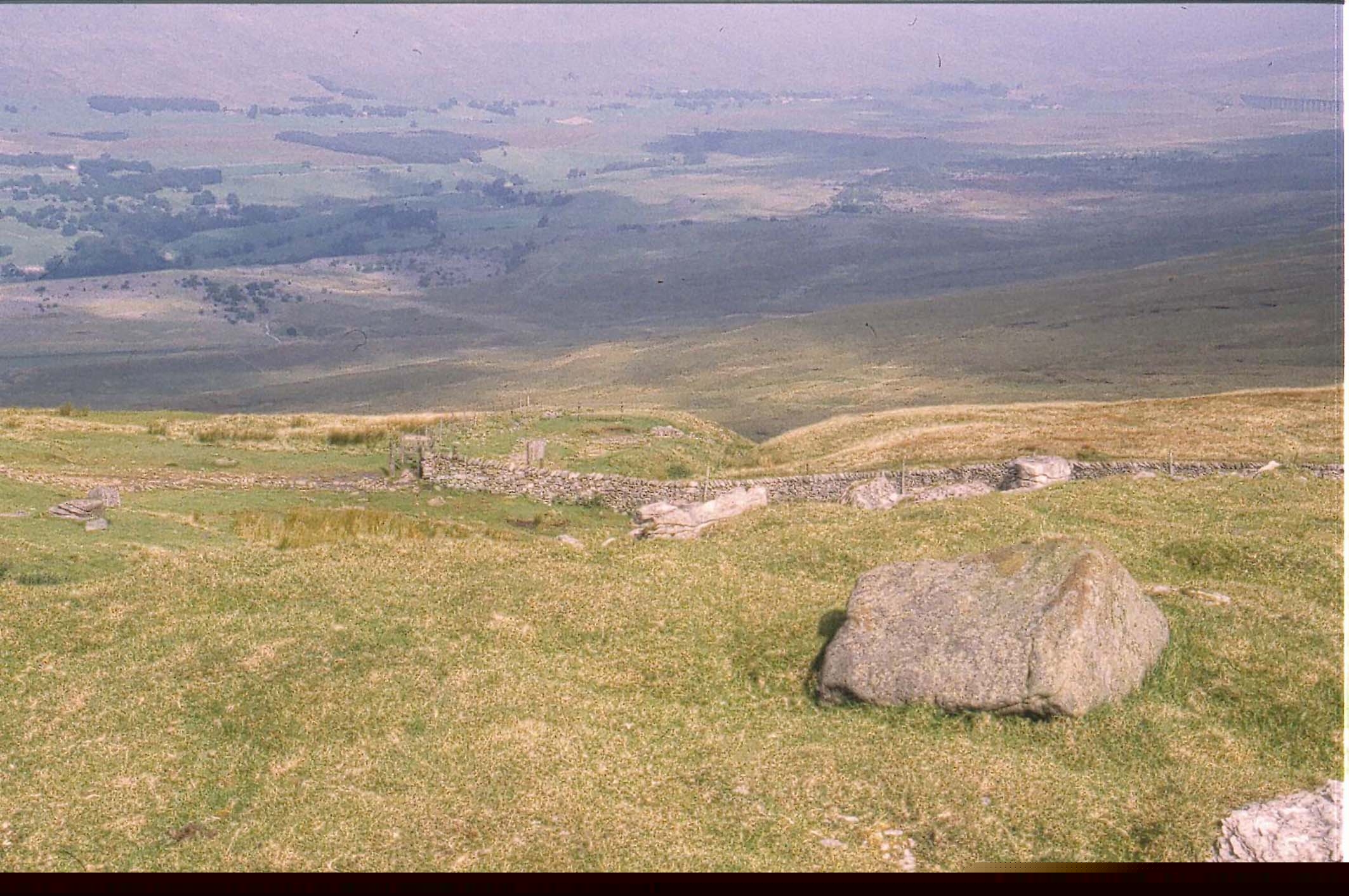
Fig 3. Merebeck from the "Spechscaflade"
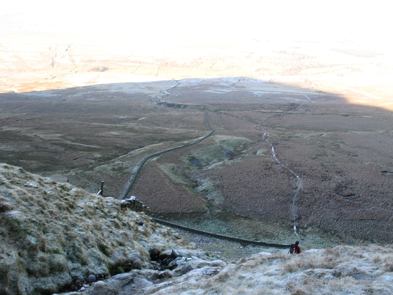
Fig 4. Showing Merebeck flowing down through Meregill
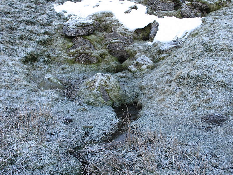
Fig 5. The source of Merebeck below the "Spechscaflade"
Fig 6. Showing the upper and lower crests on the northwestern side of Park Fell
Fig 7. The "Spechscaflade" (centre right) and the path descending from Ingleborough (centre foreground.) The wall shows the present day boundary. Our proposal is that the section of the wall in the distance is on the line of the old Selside boundary and probably continued in a straight line to the top of Ingleborough therefore bypassing the "Spechscaflade". The modern wall in the foreground is probably positioned to avoid the peat bog to the east (i.e. to the right of the wall.)
Fig 8. The 'Hill' of the Tynwald in the foreground as described by Megaw.
Photograph from the BBC Isle of Man web site.
Bibliography
Atkinson, Rev. J.C. (ed)., (1886) The Coucher Book of Furness Abbey Part 1. Chetham Society Vol 9, pp 202.
Brownbill, J. (ed)., (1916) The Coucher Book of Furness Abbey Vol 11 Part 11 -Souterschales 2. The Chetham Society Vol 76, pp 325 - 328.
Hall, J.R., Clarke (1855) reprinted (2008), A concise Anglo Saxon Dictionary. The 2008 version has a supplement by Merritt, H.D. University of Toronto Press in association with the Medieval Academy of America.
Higham, M., (1992) The Regione Dunutinga û A pre conquest Lordship? Centre for Northwest Regional Studies No 6 Summer 1992. Lancaster University pp 43 - 48
Megaw, B., (1978) Norsemen and Native in the Kingdom of the Isle û A reassessment of the Manx Evidence in B.A.R. No 54 1978 (ed) Peter Davey pp 265-314. Oxford.
Smith1, A H., (1961) The Place Names of the West Riding of Yorkshire Vol 35 Part 6 - The Wapentakes of East and West Staincliffe and Ewecross. English Place-Name Society Cambridge pp 248
Smith2, A H., (1962) The Place Names of the West Riding of Yorkshire Vol 36 Part 7 - The Wapentakes of East and West Staincliffe and Ewecross. English Place-Name Society Cambridge pp 131- 132
Smith3, A. H., (1956) English Place name Elements Vol 26 Part 2. English Place-Name Society, Cambridge pp 99.
*NB
These transcripts of Ingleborough Estate Records from Northallerton Record Office were kindly provided by Helen Sergeant. Helen notes that they were drawn up in the middle of the 19th Century (possibly by a member of the Farrer family) when there was a dispute over where the boundary between the Manors of Newby and Dent lay in the region of Whernside and Bleamoor.
Photographs
Front cover: View along Park Fell with Spechscaflade in center of photograph.
Figs 2 to 7 and front cover photographs by Arthur Batty.
by David Johnson
There can be no disagreement about the meaning of the last element in the word - 'lade' - as the same word is still in use today, at least in Scotland if not elsewhere, to mean a water course or a launder feeding into a water mill. The controversy surrounds the two other elements, especially the middle 'scaf'.
In Old Norse the words used to describe the meeting, or 'thing', site were either ■iksta■ or ■ingstar. The ■ letter was pronounced rather as our 'th' or 'f', hence ■iksta■ would sound something like 'thickstaf' and the would sound like 'thingstadr' (with a wierd 'd' sound, I believe). It is easy, therefore, to transmute scaf into staf, or vice versa, given ther passage of many centuries. Taking this route, it has nothing whatsoever to do with crooked. 'Spech' probably does mean place so the full meaning, using this line of thought, is the 'stream at the thing (ie meeting) place'. Even if the argument presented to translate 'scaf' as 'crooked' is valid, this does not in any way justify saying that this means the Mearbeck site was the spechscaflade. It is simply a jump too far. Again, if 'scaf' is taken to derive from 'sceaf', I would argue similarly. If it is 'source', then the very short stream, that rises at a spring, is indeed a source so could be used to support Yvonne's line of reasoning. However, if it means boundary pole, then once again this is a jump too far as this presupposes that the medieval boundary went from Park Fell to the top of Ingleborough and then did a tight dogleg back to follow Mearbeck. To my mind, this is inconceivable.
David Johnson